$15,000
$21,000
28.6%For more information regarding the value of a property, please contact us for a free consultation.
0 PAINTED ROCK DAM Road #- Gila Bend, AZ 85337
4.62 Acres Lot
Key Details
Sold Price $15,000
Property Type Vacant Land
Listing Status Sold
Purchase Type For Sale
MLS Listing ID 6421902
Sold Date 06/05/24
HOA Y/N No
Originating Board Arizona Regional Multiple Listing Service (ARMLS)
Annual Tax Amount $57
Tax Year 2021
Lot Size 4.617 Acres
Acres 4.62
Lot Dimensions 340' x 495' x 515' x 471'
Property Description
Here's an off the grid large 4.61 acre parcel about 20 miles to the west of Gila Bend. It's approximately 1.75 miles south of the I-10 freeway. This is a buildable lot with numerous possible uses to choose from or you might have some ideas of your own.
For full list of zoning ordinances, contact seller with email address, or contact Maricopa County Planning and Zoning at (602) 506 3301 with parcel id 403 41 002H. There could be many uses for this parcel. Some possibilities that come to mind, but please verify with Maricopa County Planning and Zoning for uses, reach them at (602) 506 3301 with parcel ID 403 41 002H.
Livestock grazing.
CBD or Hemp farming (You will need required permits to be legal).
Beekeeping.
Vineyard.
Solar or wind farm.
Fallout shelter (if concerned about the state of the global situation).
Earth bermed home.
Fishing ponds.
Astronomy purposes.
Animal sanctuary.
Passive solar greenhouse.
RV Storage.
Horse stable.
Perhaps many more possibilities.
Once again, the parcel id is 403 41 002H when you need to share.
There is no electricity and no water. You would have to provide your own power source (some companies provide lease to own solar panels for 0 or very little down), place septic or other disposal system, and dig a well in order to live on the property. However, this lot is buildable. Please call the Maricopa County Planning and Zoning Department for information on permit for building. The parcel ID # is 403 41 002H and the Planning and Zoning phone number is (602) 506 3301.
To dig a well, you will need a permit from the Az Department of Water Resources. Their phone number is (602) 771 8500.
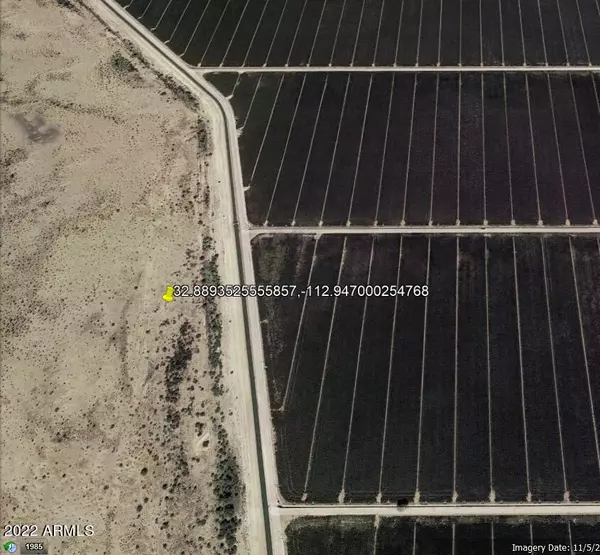
GPS Coordinates 32.8893525555857, -112.947000254768
From Phoenix, I-10 west to I-8 through Gila Bend, to Citrus Valley Rd, see map to locate property.
There is a large 270 acre working farm bordering just to the east.
AWT or 4WD vehicle is recommended since in order to access the acreage you will need to have a way to get over a railroad track on the road from I-10 approximately 2 miles away. Perhaps contact the railroad for assistance, hours of crossing etc. Please be safe if crossing the railroad track. There may be a roundabout back way in through land to the east and south.
Property priced for easy sale. If you were purchasing 4.61 acres inside the Phoenix Metropolitan area, it would cost you between $500,000 and $1,000,000. So look at this parcel, consider going off the grid and saving a lot of money.
Please due your due diligence and if you are interested, owner/agent may negotiate seller carry back with sufficient down payment.
Property priced for easy sale under county tax assessed value of $37,300 for 2023, which tends to be 2/3 of market value.
Manager/principal of selling entity is a licensed Arizona realtor.
Location
State AZ
County Maricopa
Zoning R190
Direction GPS COORDINATES: 32.8893525555857, -112.947000254768
Exterior
Waterfront No
Building
Sewer None
Water None
Others
Senior Community No
Tax ID 403-41-002-H
Acceptable Financing Seller May Carry
Horse Property Y
Listing Terms Seller May Carry
Financing Cash
Special Listing Condition Owner/Agent
Read Less
Want to know what your home might be worth? Contact us for a FREE valuation!

Our team is ready to help you sell your home for the highest possible price ASAP

Copyright 2024 Arizona Regional Multiple Listing Service, Inc. All rights reserved.
Bought with My Home Group Real Estate

Bob Nathan
Global Private Office Advisor & Associate Broker | License ID: BR006110000
GET MORE INFORMATION


